Atlantis Arisen
April 18, 2024, 01:14:54 pm
Welcome, Guest. Please login or register.

Login with username, password and session length
News: Tiny Galactic Building Blocks Spotted
http://www.space.com/scienceastronomy/070906_toy_galaxies.html
 
  Home Help Search Arcade Links Staff List Login Register  

Saya de Malha Bank

Pages: [1]   Go Down
  Print  
Author Topic: Saya de Malha Bank  (Read 1684 times)
0 Members and 1 Guest are viewing this topic.
Brandi1
Atlantean Warrior
***
Posts: 39


View Profile
« on: February 08, 2011, 01:23:49 pm »

Saya de Malha Bank


The Saya de Malha Bank (also Sahia de Malha Bank, Modern Portuguese: saia de malha, English mesh skirt) is the largest submerged bank in the World, part of the vast undersea Mascarene Plateau. It lies east of Madagascar, southeast of the Seychelles, and north of the Nazareth Bank, the Cargados Carajos shoals, and the island of Mauritius, and falls into the Mauritian exclusive economic zone. The closest land is the tiny Agalega Islands (a remote dependency of Mauritius), some 300 km further west, followed by the southern Seychellois island of Coëtivy, some 400 km northwest. Mauritius administers Saya de Malha Bank as part of its Exclusive Economic Zone.

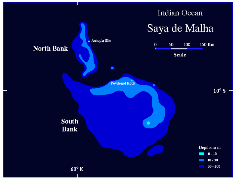
The bank covers an area of 40,808 km2 (15,756 sq mi),[1] and is composed of two separate structures, the smaller North Bank (also called Ritchie Bank), and the huge South Bank. If the South Bank were recognized as a submerged atoll structure, it would be the largest of the world, almost three times the size of the Great Chagos Bank, commonly considered the largest atoll structure of the world. Even smaller North Bank would be one of the largest atolls worldwide. The North Bank and the South Bank appear to have different origins, since they are separated by a fault. Studies show that the South Bank and the Great Chagos Bank were one single feature until about 64 to 69 million years ago, when an ocean ridge opened between them and started pushing them apart.

Saya de Malha Bank consists of a series of narrow shoals, with depths from 17 to 29 meters on the rim. They are arranged in a semicircular manner, around a space, the former lagoon, about 73 meters deep, which slopes on the Southeast. Some areas of the bank are shallow, less than 10 meters below the surface. The shallowest sites known are Poydenot Rock, at a depth of 8 meters, and an unnamed site 145 km further northwest, with a depth of 7 meters. The banks are covered with sea grass interspersed with small coral reefs. Due to its remote location, the bank is among the least-studied shallow marine ecoregions on the planet. The banks are a breeding ground for Humpback Whales and Blue Whales.

Report Spam   Logged

Share on Facebook Share on Twitter

Brandi1
Atlantean Warrior
***
Posts: 39


View Profile
« Reply #1 on: February 08, 2011, 01:24:20 pm »

HistoryThe bank was named by Portuguese explorers 500 years ago, who encountered the bank on the voyage between the Cape of Good Hope and India. After traversing miles of deep blue Indian Ocean, they found themselves sailing above a shallow area of the bank, covered with swaying green seagrass.

The first serious survey of the bank was undertaken by Captain Robert Moresby of the Royal Navy in 1838. Moresby previously surveyed the Laccadives, the Red Sea, the Maldives and the Chagos Banks. Due to Moresby's ill health, the Saya de Malha bank was his last survey in a long and brilliant career exploring and charting the archipelagos and reefs of the Indian Ocean.

Report Spam   Logged
Brandi1
Atlantean Warrior
***
Posts: 39


View Profile
« Reply #2 on: February 08, 2011, 01:25:06 pm »

GeologyThe bank was formed 35 million years ago by the Réunion hotspot, and is composed of basaltic basal rock overlain with limestone. The limestone banks found on the plateau are the remnants of coral reefs. Millions of years ago, the bank was one or more mountainous volcanic islands, like present-day Mauritius and Réunion, which subsequently sank below the waves. Some of the banks may have been low islands as recently as 18,000 - 6,000 years ago, when sea levels were up to 130 meters lower during the most recent ice age.

Report Spam   Logged
Brandi1
Atlantean Warrior
***
Posts: 39


View Profile
« Reply #3 on: February 08, 2011, 01:25:14 pm »

Artificial island projectThe Saya de Malha Bank is, or was, the site of an attempt to create an artificial island by Wolf Hilbertz (1938-2007) and Dr. Thomas Goreau. Hilbertz created seacrete and biorock, by combining the minerals in sea brine with electricity to create an artificial coral, or building materials. Hilbertz and Goreau made several expeditions to the bank to attempt to create or grow an island around a steel structure that has been anchored to the North Bank sea floor at a depth of 11 meters. Some sources say that the island would have been named Autopia or Autopia Saya, and declared a micronation.

Excerpt from an online interview with Wolf Hilbertz in Celestopea Times, 2004

You and your discovery of accreting minerals in seawater into solid forms has inspired several groups over the years to contemplate creating artificial islands for their piece of paradise. Your name has been linked to some such as Autopia Ampere and Skerki Bank. Is there an update on either of those projects or words of encouragement for others seeking something similar?
Examining the geography and bathymetry of the globe to find a spot in the ocean where to establish a permanent research settlement I came upon Seamount Ampere, east of Gibraltar, and Skerki Bank near Sicily. Both sites had potential, but Saya de Malha Banks in the NE Indian Ocean eclipsed them all. Having about the size of Belgium, most of Saya lies in international waters, 'in the high seas' legally speaking, governed only by the U.N. Law of the Sea. In 1997, Goreau and I sailed to Saya de Malha's many shallow sites and established the first accretion structure there, powered by floating photovoltaics and thus claiming the banks. In 2002 the second Saya de Malha Expedition with three boats laid the foundation of Autopia Saya, powered by photovoltaics, and performed the first modern bathymetric surveys ever conducted in the area. The latest Saya de Malha Expedition Report is on our websites. We are busy now organizing a third expedition to get Autopia Saya growing above sea level.
Mauritius claims the Saya de Malha Bank as part of its Exclusive Economic Zone. In the similar situation, Tonga evicted the Republic of Minerva from the Minerva Reefs by arguing that they had established a claim over that non-adjoining underwater site by traditional fishing use.

Report Spam   Logged
Brandi1
Atlantean Warrior
***
Posts: 39


View Profile
« Reply #4 on: February 08, 2011, 01:25:26 pm »

References^ http://ftp://rock.geosociety.org/pub/reposit/2001/2001075.pdf
Report Spam   Logged
Pages: [1]   Go Up
  Print  
 
Jump to:  

Bookmark this site! | Upgrade This Forum
SMF For Free - Create your own Forum

Powered by SMF | SMF © 2016, Simple Machines
Privacy Policy