Show Posts Show Posts
|
|
Pages: [1] 2
|
|
1
|
the Unexplained / Cryptozoology / Did Bigfoot take a big trip east?
|
on: May 11, 2010, 01:29:55 pm
|
Did Bigfoot take a big trip east? Go ahead and scoff, but a Minnesota hunter's camera captured an image of a 7-foot-tall, black creature. By BOB VON STERNBERG <http://www.startribune.com/bios/10646151.html> , Star Tribune Last update: December 10, 2009 - 9:33 PM  Tim Kedrowski admits he was "super skeptical" at first. But now the 55-year-old salesman from Rice, Minn., wonders if his motion-activated camera managed to do something no one else has -- capture Bigfoot in Minnesota's big woods, far from his alleged stomping grounds in the Pacific Northwest. Kedrowski's two adult sons set up the camera on the family's hunting land near Remer, Minn., and Leech Lake to see what animals might trigger it -- never expecting a black creature about 7 feet tall to stride through a stand of trees in late October. Scientists, no doubt, will scoff as they always do, but Kedrowski's photo of the big lug, more formally known as Sasquatch, has given believers renewed hope that the creature might exist. "I can't sit here and tell you I'm a 100 percent believer, but I'm a little less skeptical than I was before," he said. "You don't go deer hunting looking for this kind of thing." Although supposed Sasquatch sightings have occasionally been reported in Minnesota over the years, most have popped up in California and the Pacific Northwest. That is, until the rainy night of Oct. 24, at 7:20 p.m., when Kedrowski's camera clicked and captured a blurry image of, well, who knows what? "We were sure it wasn't a bear and wasn't someone pulling a scam on us," Kedrowski said. "We thought it might be a bow hunter out looking for a wounded deer -- that's the only reason anyone would be out there in the dark that time of night." His sons -- the only people who knew the camera was even there -- initially thought the other had pulled a scam. But both were far from the hunting land that night. Although it remains possible that it was someone in an animal suit, "that'd have to be a hell of a big person," Kedrowski said. He said two elderly men who live closest to the site told him that late that night they had gone outside to use their outhouse and had heard strange squealing noises. When asked to show the direction of the sounds, they pointed to the area where the camera had been. Kedrowski remained skeptical of the photo's veracity, until he contacted Don Sherman and Bob Olson, who style themselves as the Northern Minnesota Bigfoot Research Team. They compared the image to one of an alleged Bigfoot photo taken years ago in California "and the features were identical," Kedrowski said. Sherman said the Northern Minnesota Bigfoot Research Team has been receiving reports of Bigfoot sightings since 2006 and has had reports every year since, including four reports this year. Local wildlife experts aren't biting. "Personally, I don't buy the fact this thing exists," said Blane Klemek, assistant wildlife manager with the Minnesota Department of Natural Resources in Bemidji, who notes that no one has ever found the carcass of a Sasquatch. "All organisms die -- they don't just go away," Klemek said. "You'd think someone someday would find one." Ever since publication of the tale -- and photo -- in the Bemidji newspaper this week, "my phone's been ringing off the hook," he said. "I tell everyone I wish I knew what it was." The Associated Press contributed to this report. Next page <http://www.startribune.com/local/78975102.html?page=2&c=y> http://www.star ribune.com/local/78975102.html?page=2&c=y Recent Local + Metro stories Cops nab suspect in alleged gun threat in Roseville <http://www.startribune.com/local/78991917.html?elr=KArks:DCiUHc3E7_V_nDaycUiacyKUzyaP37D_MDua_eyD5PcOiUr> - December 10, 2009 Cops nab suspect in alleged gun threat in Roseville <http://www.startribune.com/local/78991917.html?elr=KArks:DCiUHc3E7_V_nDaycUiacyKUzyaP37D_MDua_eyD5PcOiUr> - SWAT officers surrounded and searched an office building after a man allegedly threatened a worker there with a shotgun. More <http://www.startribune.com/local/78991917.html?elr=KArks:DCiUHc3E7_V_nDaycUiacyKUzyaP37D_MDua_eyD5PcOiUr> Wis. legislators: Minn. has rejected tax offer <http://www.startribune.com/local/79068212.html?elr=KArks:DCiUHc3E7_V_nDaycUiacyKUzyaP37D_MDua_eyD5PcOiUr> - December 10, 2009 Wis. legislators: Minn. has rejected tax offer <http://www.startribune.com/local/79068212.html?elr=KArks:DCiUHc3E7_V_nDaycUiacyKUzyaP37D_MDua_eyD5PcOiUr> - Wisconsin legislators say Minnesota officials have rejected a plan to continue tax reciprocity. More <http://www.startribune.com/local/79068212.html?elr=KArks:DCiUHc3E7_V_nDaycUiacyKUzyaP37D_MDua_eyD5PcOiUr> |
|
|
|
|
2
|
Archaeology / Archaeological Evidence / Scientists discover oldest footprints on Earth
|
on: May 11, 2010, 01:28:24 pm
|
Scientists discover oldest footprints on Earth January 7, 2010 10:14 a.m. EST A model representing what a tetrapod may have looked like. STORY HIGHLIGHTS Scientists discover fossilized footprints of 395 million-year-old four-legged creature Discovery pushes the evolutionary scale back by nearly 20 million years Compared in significance to discovery of the first miocene hominoids RELATED TOPICS Geology Nature and the Environment (CNN) -- Scientists have found the oldest fossilized footprints made by a four-legged creature forcing a rethink on when fish first crawled out of water and onto land. The discovery of the footprints in a former quarry in the Holy Cross Mountains in south-eastern Poland are thought to be 395-million years old -- 18 million years older than the earliest tetrapod (a vertebrate with limbs rather than fins) body fossils. The report published Thursday in the science journal Nature says the footprints of the tetrapod measure up to 26 (10 inches) centimeters wide, which scientists say is indicative of an animal around 2.5 (7.5 feet) meters in length. The footprints are also 10 million years earlier than the oldest known elpistostegids -- creatures which displayed some animal characteristics but retained fins. Philippe Janvier from the Museum National d'Histoire Naturelle in Paris, and reviewer of the paper told CNN: "It is a really stunning discovery because it's the earliest evidence we have of tetrapods. These footprints are clear enough to attest that tetrapods were there 395 millions years ago." The report's authors say their findings "force a radical reassessment of the timing, ecology and environmental setting of the fish-tetrapod transition, as well as the completeness of the body fossil record." As well as finding fossilized footprints, Per Ahlberg, Professor of Evolutionary Organismal Biology, Uppsala University, Sweden and his co-authors from the Polish Geological Institute in Warsaw also report finding several tracks of different sizes and characteristics. The tracks, they say, have distinctive 'hand' and 'foot' prints and no evidence of a dragging body. Ahlberg said in a video on the Nature Web site: "The trackway shows pairs of prints -- the sort of tracks a salamander would leave if it walked. In order to make tracks like the ones found you need to have front legs and back legs that are about the same size." Ahlberg said the disused quarry where the fossils were discovered has yielded some of the most exciting finds he has encountered in his career as a paleontologist. Although Janvier describes the lack of skeletal evidence as "frustrating" it doesn't undermine the importance of the discovery. "It changes what we thought about the evolutionary tree concerning the part dealing with transition from fish to land vertebrae." Janvier said. "The divergence between the tetrapods and their closest fish relatives is much younger than previously thought and it obliges us to find actual evidence -- skeletons or complete fossils -- in much earlier strata that could enlighten us between this divergence." |
|
|
|
|
3
|
Atlantis / Atlantis & the Atlantic Ocean / Re: The (not so) Fortunate Islands
|
on: May 11, 2010, 01:26:43 pm
|
My conclusion is that the Guanches lost their advanced knowledge in a flood, which resulted in the fact that their culture degenerated for many millennia because there was no contact with the outer world. In the mean time, that outer world continued to progress with the Egyptians, and later the Romans, Greeks and Phoenicians. The Guanches were isolated from the rest of the world, and they were heading back towards the Stone Age in their time machine of amnesia. Sources: * Timaeus and Critias (360 B.C.): Benjamin Jowett translations * The Canary Balcony: http://home.pi.be/~p4u00071/canarias/can-eng.html#menuitems * Atlantisquest: http://www.atlantisquest.com * Shadowlands website: http://www.theshadowlands.net/atlantis/ * Atlan: http://www.atlan.org/ * Factmonster website: http://www.factmonster.com/ce6/world/A0856755.html * Graham Hancock: Fingerprints of the Gods (1994 edition) * Andrew Collins website: http://www.andrewcollins.net * The 1911 Encyclopedia: http://43.1911encyclopedia.org * Sunrise Magazine, August/September 1999 * Lonely Planet website: http://www.lonelyplanet.com/destinations/europe/canary_islands/environment.htm * USGS/Cascades Volcano Observatory, Vancouver, Washington : http://vulcan.wr.usgs.gov/Volcanoes/CanaryIslands/description_canary_islands_volcanics.html * Website of Bryan Cousens: Research Adjunct Professor Igneous Petrology and Isotope Geochemistry: http://www.carleton.ca/~bcousens/volcanopage.html * Wave of disaster warning: http://www.guardian.co.uk/Print/0,3858,4246811,00.html * New York Times May 21, 1978: article on Soviet expedition on the Atlantic Ampere Seamount, cited on various sites on the internet. * Jules Verne: 20,000 Leagues Under The Sea * Dutch site with information on Guanches & Atlantis: http://www.home.zonnet.nl/pollie_37/Atlantis_2.html * Jonah G. Lissner: Evidence for the Ancestors of the Guanches as Founders of Predynastic Egypt : http://joe3998.tripod.com/guanches/ * Charles Berlitz: The Lost Ship of Noah * Talk Origins page on Cro Magnons: http://www.talkorigins.org/faqs/homs/cromagnon.html * Info on Djosers step pyramid: http://ccat.sas.upenn.edu/arth/zoser/zoser.html * Photographs of Djosers step pyramid: http://www.waseda.ac.jp/projects/egypt/sites/pyramids/saq03/saq03ph-E.html * Fred Olsen: Pirámides de Güímar: http://www.fredolsen.es/piramides/index.htm * Institutum Canarium: http://www.institutum-canarium.org/[/QUOTE] http://www.grahamhancock.com/forum/VandecruysG1.php?p=1 http://atlantisonline.smfforfree2.com/index.php/topic,15476.0.html |
|
|
|
|
4
|
Atlantis / Atlantis & the Atlantic Ocean / Re: The (not so) Fortunate Islands
|
on: May 11, 2010, 01:25:20 pm
|
|
Influence on Egypt: The Guanches mummified their dead and the mummification techniques they used were almost identical to those used in ancient Egypt, although fact is that the Egyptians attained a higher form of perfection. Both cultures would balm the bodies before removing the internal organs that were kept aside in special vases. Also the bandages were used the same way, and similar offering in both cultures complete the circle.
Influence on America: there are pyramids on the Canaries that resemble monuments from ‘the opposite continent’
like in Mexico and Peru, and they seem to be aligned to the sunset on the summer solstice. But I wouldn’t exclude a link with Egypt either, because the alignment reminds me of Giza and the basic shape makes me think of for example Djoser’s step Pyramid from the Third Dynasty. Their purpose though was completely different and the Canary pyramids didn’t have an inside.
Influence on Greece: just like the Atlas we know from Greek mythology the Guanche god Achaman ‘he who carried the world’ was depicted as a mountain that separated heaven and earth, or as carrying heaven on his shoulders.
Furthermore the first King of Atlantis was called Atlas. This suggests they were actually one and the same.
When Thor Heyerdahl started investigating the pyramids on the Canaries, many people claimed them to be nothing more than piles of rubbish, despite the fact that the Guanches themselves tell us about these pyramids and their rituals involving these monuments. A central point in their religion was the belief that if their main pyramid collapsed, it would mean the end of their island in the same way Atlantis sunk.
Unlike what many people think, the Canary Islands didn’t get their name from the birds who share their name, but
from the dogs that lived on the islands. The Latin name of the islands was ‘Insulae Canariae’ or Islands of dogs.
These dogs were a central part in the religious culture of the Guanches, with a position just under Achaman, who was
the Canary equivalent of the Greek Atlas. Dogs were also an important part of the Egyptian culture. Take for example their god Anubis, always portrayed as a man with the head of a dog.
The Canary Ridge we described earlier in this survey is such an uplifted part of the earth and much of the religion of the Guanches is also about such a disaster. In their culture there was a group of holy virgins, called the Harimagada. Every year this group jumped in the sea and
drowned. With this voluntary offer they tried to prevent that their island would sink in the sea.
Sopdit, the Egyptian god whose appearance on June 15 in the form of the dog star meant the start of the new year,
was honored as ‘the western’ and the story goes that he documented the history from before the Great Flood, that
destroyed his ‘island-house’ in the far West.
|
|
|
|
|
5
|
Atlantis / Atlantis & the Atlantic Ocean / Re: The (not so) Fortunate Islands
|
on: May 11, 2010, 01:25:04 pm
|
“Each of the ten kings in his own division and in his own city had the absolute control of the citizens, and, in most cases, of the laws, punishing and slaying whomsoever he would. According the Plato the Atlanteans were amongst the best sailors in the world. Despite the fact that the Guanches didn’t know how to build boats, there is evidence on the islands that once they did have this knowledge. This evidence comes in the form of rock art like for example in Pico de Don David on Fuertaventura: here we find a very clear drawing of a large ship. This is certainly not a little boat used on a lake or river, but undoubtedly a vessel that was perfect for ocean expeditions. And there is more: a central characteristic of the Atlantean empire was the use of a mixture of red, black and white stones. This extraordinary combination, most probably of volcanic origin, can be found all over the Canaries. On Lanzarote, the Guanches built long, conic pillar-like monuments in red, black and white stone. Due to seismic activity on the islands all except one collapsed. This remaining monument can be visited at the coast near Arrecife. These three colour designs are also found in rock paintings like the ones in the Cueva Pintada (painted cave) on Gran Canaria. That is the evidence we can confirm today, but there are also reports from temples in the same three colours. Unfortunately the Christians destroyed all of them. The best-preserved ruin can be found on La Palma. Called Efeguen, their resemblance with Atlantean architecture does not limit itself to just the colour scheme, but also the construction designs. The Efeguen consisted of 2 concentric walls, one inside the other. Then in the centre of the inside wall there was a large altar, placed on a platform. This could be a reference to Poseidon’s altar, placed in a temple in the centre of the city. The resemblance is certainly there, and perhaps the Guanches built these temples, of which they remembered the basic shape from a distant past, as a way to remember and honour their ancestors. -------------------------------------------------------------------------------- http://www.grahamhancock.com/forum/VandecruysG1.php?p=1 |
|
|
|
|
6
|
Atlantis / Atlantis & the Atlantic Ocean / Re: The (not so) Fortunate Islands
|
on: May 11, 2010, 01:24:48 pm
|
|
Plato’s writings of how the Kings of Atlantis would meet at a central point on the island to discuss laws and politics
definitely resemble the Guanche culture. Just like the Atlantean kings the Guanche kings would meet at a ‘Tagaror’ or meeting place to vote new laws and hold political debates. The reader will notice how this doesn’t fit for Stone
Age people. On Tenerife there were 9 little kingdoms and a neutral area in the middle.
The 9 kings or Menceys as
they called themselves ruled there piece of land as if it was a country. Each kingdom knew three classes: the
monarchy, the nobility and the lower class.These social structures might seem a bit ridiculous because the island is really not that big, but they could be based on a memory from the past they tried to copy on their island. An extract
from Critias explains the link with Atlantis:
|
|
|
|
|
7
|
Atlantis / Atlantis & the Atlantic Ocean / Re: The (not so) Fortunate Islands
|
on: May 11, 2010, 01:23:47 pm
|
|
Anno Domini 1331: it was the year when the first Portuguese sailor set foot on Canary grounds, rediscovering an
inhabited archipelago that, until then, had existed in almost perfect isolation from the rest of the world. The peaceful
isolation for both the islands and their people would soon come to a brutal end, because many more ships would
follow. But who were these islanders and where did they come from? Fact is that their presence on these islands was a strange anomaly given their position near the African continent. They were tall, had a light skin colour and often blonde hair: not exactly what you would expect in these regions! They were called ‘Guanches’, from Guan
Chenech or Man from Chenech, as they themselves called the island Tenerife. In time, that name became common for
the inhabitants of the whole archipelago. How and when they got there is unknown, because they even lacked the knowledge to build boats. Scientists said they couldn’t have been there thousands of years before Plato’s time, but new evidence from archaeological examinations indicates a human presence on the islands from at least 4,000 BC (so maybe earlier), redefining the accepted view for inhabitation of the islands.
It looks like the European explorers found the last tribes of pure Cro-Magnon origin, which explains their physical features. The Cro-Magnon’s were Homo Sapiens Sapiens, and lived between 45,000 and 10,000 years ago. They were the first modern people in both physical appearance and intellect. Gradually they replaced the Neanderthals in
Europe. It seems that somehow the Guanches survived the extinction of the Cro-Magnon man, probably because life
was quite easy on their isolated islands. However, their culture seems to be evolving in a downward spiral. Instead
of innovating and advancing technologically and culturally, they seem to degenerate back to a Stone Age culture.
The origin of the Guanches remains a mysterious haze. Researchers linked them with the Berbers from North Africa,
but in Charles Berlitz’s ‘The Lost Ship of Noah’ we read that they told the Spanish that they had always thought they
were alone on the earth and that everyone else drowned in the Great Flood. It is not such a big step to link them with Atlantis, because they believed they once lived in a large land with cities, fertile plains and rivers. At a certain moment in time this prosperous empire was flooded and only a few people managed to escape death by climbing on the volcanic top Teide. The Canary Islands would be the highest peaks of this sunken civilization. This archaic memory is intriguing to say the least.
On various places on the islands ancient inscriptions have been found, but in the 14th Century the Guanches had long
forgotten their meaning. There are important differences in these inscriptions: there seem to be signs resembling the Phoenician and Numidian alphabet, but probably this wasn’t their original script, because I also found pictures of petroglyphs depicting strange symbols that look like a script. It seems like the Guanches simply forgot how to read and write. Adding up the facts definitely rings a bell to anyone who read the Timaeus & Critias dialogues, because the Atlanteans too forgot their knowledge of the written word.
|
|
|
|
|
8
|
Atlantis / Atlantis & the Atlantic Ocean / Re: The (not so) Fortunate Islands
|
on: May 11, 2010, 01:23:26 pm
|
For discoveries in that region we had to wait until 1981, when an expedition lead by Pippo Cappellano found some mysterious ruins with strange carved symbols on the ocean floor near the coast of Lanzarote. At a depth of about 50 feet and over an area of 900 square feet, they found large flat stones that look like they were carefully put into place. These blocks were followed by wide stone steps. But that’s not all. On the other side, near the Moroccan coast, a several miles long undersea wall has been discovered and photographed. What is hidden on the bottom of the Atlantic? Are these the remains of the sunken civilization Atlantis? Like with the Yonaguni structures, many orthodox scientists claim they are natural forms, without adequate research, seemingly to avoid having to admit any mistakes in our history books. The underwater structures in the Canary region were found at a depth of only 50 feet. That means they were probably still above water some 2000 years ago. Therefore researchers concluded that Romans, Greeks or Phoenicians must have built them. But none of them ever colonized the Canaries, so what would drive them to build these structures? There is indeed evidence, like some Roman amphoras, that indicates Europeans stopped by in the region, but their presence was probably of no substantial importance. It seems more logical to follow another path. Not everything of Atlantis sunk, so these structures could still be the last remains of the empire, swallowed by the sea around the time of Christ. -------------------------------------------------------------------------------- http://www.grahamhancock.com/forum/VandecruysG1.php?p=1 |
|
|
|
|
9
|
Atlantis / Atlantis & the Atlantic Ocean / Re: The (not so) Fortunate Islands
|
on: May 11, 2010, 01:23:14 pm
|
The damage would be enormous, probably worse than we could ever imagine, easily reaching the African coast and the South of Europe with Portugal and Spain. Buildings would be swept away like card houses. Of course the Canaries themselves wouldn’t be spared either. Simon Day of the Benfield Greig geohazard research centre at University College London said: “The first wave is going to come in, maybe take out the first few blocks, take the debris away, flatten the ground. The next wave takes out blocks progressively further inland. Over a large part of the area that is inundated, you will be seeing near-total destruction." Tsunamis are active in the complete water mass from the ocean floor all the way to the surface, unlike regular waves that only affect the water near the surface. Therefore these giant waves tend to start going faster in deeper parts of the ocean . If this is possible today, it’s certainly an option that at the end of the last Ice Age in this highly volcanic zone tsunamis of the same kind took place, triggered by volcanic eruptions and seismic activity. This could have meant the end of Atlantis, and following Dr. Simon Day’s statement about the effects of the waves, it is not such a big surprise that today we find none or only a few traces of this once great civilization. The remains of Atlantis could be widely spread on the ocean floor by the power of the water, perhaps covered with lava, sand and rocks. -------------------------------------------------------------------------------- http://www.grahamhancock.com/forum/VandecruysG1.php?p=1 |
|
|
|
|
10
|
Atlantis / Atlantis & the Atlantic Ocean / Re: The (not so) Fortunate Islands
|
on: May 11, 2010, 01:22:59 pm
|
|
The waters surrounding the Canaries are a true paradise for divers, and certainly not only because of the underwater fauna and flora. It seems like the same volcanic surface we find on the islands continues under water: volcanic rock formations, caves, tunnels, lava reefs. This shows that at some point in history volcanic eruptions and lava floods
changed the appearance of the ocean bottom in this region, maybe even hiding traces of Atlantis under a tick layer of
lava. Lanzarote, for instance, experienced in the 18th century a 6 years long volcanic eruption, altering a significant
part of its surface. Furthermore little is known about the ‘original’ ocean floor: it’s not exceptional for large parts to slide under the mantle again and disappear in the burning depths of the earth. In this process, deep trenches are formed in the ocean. This could have happened in the Canary region as well.
But how dangerous is this area geologically? And are disasters likely to happen there again? Unfortunately the
answer seems to be yes. In an article that appeared in the Guardian Newspaper in August 2001 British and US scientists warn that an eruption of the Cumbre Vieja on La Palma could cause one of the worst disasters in the history of mankind. In that article we read:
“A lump of rock twice the volume of the Isle of Man would slide down theunstable western flank of the mountain at more than 200mph and travel up to 40 miles along the sea floor. This would set off the worst tsunami, or giant wave, ever recorded.” (The Guardian, August 29, 2001)
|
|
|
|
|
11
|
Atlantis / Atlantis & the Atlantic Ocean / Re: The (not so) Fortunate Islands
|
on: May 11, 2010, 01:22:43 pm
|
The Canary archipelago consists of 7 islands, but when the Portuguese discovered the islands, stories were being told about an eighth island, that was sometimes seen to the West of La Palma, El Hierro and La Gomera. When sailors tried to reach it, the island was covered in mist and disappeared. Stories about ghost islands like this one seem imaginative tales at first, but there may be some form of truth in it. In 1867 an island suddenly rose from the sea near Terceira in the Azores, but only a few days later it was swallowed again by the sea. Maybe the eighth island was not just a story either, because events like this are indeed possible in this region, as the Canaries lay in a highly active volcanic zone. The seven islands and six islets of the Canaries are in fact the emerged tips of a volcanic mountain range, situated just West of the African Continental Margin and hidden by the Atlantic Ocean. This means that under the surface of the deep blue ocean they are connected. It is a fact that the waters surrounding the islands are very deep, but to say they all rise directly from the ocean floor is just not a correct statement. It would only be true for part of the archipelago, more specifically the western part with Tenerife, La Palma, El Hierro and La Gomera. These islands are indeed volcanic peaks going all the way down to the deep Atlantic floor. Lanzarote, Fuertaventura and the six islets though are flatter islands, yet also volcanic, but emerging from a submarine plateau, known as the Canary Ridge. This ridge rises approximately 4,600 feet from the bottom of the ocean. Because of the extreme volcanism in this region (the whole archipelago was formed after volcanic eruptions and it is said that the volcanism in the area is the result of a mantle hotspot under the islands), it is possible that once a landmass in this area was above the surface, and did not just sink because of the rising of the sea level, but more because of seismic activity such as earthquakes and tsunamis combined with or caused by volcanic eruptions at the end of the last Ice Age. -------------------------------------------------------------------------------- http://www.grahamhancock.com/forum/VandecruysG1.php?p=1 |
|
|
|
|
12
|
Atlantis / Atlantis & the Atlantic Ocean / The (not so) Fortunate Islands
|
on: May 11, 2010, 01:22:22 pm
|
The (not so) Fortunate Islands
« on: January 12, 2009, 02:53:12 am »
--------------------------------------------------------------------------------
The (not so) Fortunate Islands Around 100 BC, a Roman author and geographer that listened to the name Marcellus, wrote that the legend of Atlantis was still being preserved on a group of islands in the Atlantic Ocean. In 450 AD Proculus Diadochus, in an attempt to verify what Marcellus had written so many centuries ago, went on a journey to the Islands of the Blessed or Fortunate Islands, located at only a day sailing off the coast of Mauretania. He could only acknowledge Marcellus findings. For centuries, the Canaries were referred to as the Fortunate Islands, as is shown on various ancient maps and descriptions. But where would someone ca. 100 BC get such accurate information on the inhabitants of unexplored islands in a far away corner of the world? Surely, he didnt go there himself! Could it be the information came from a much older source? In his Topographia Christiana, a description of the universe, Cosmas Indicopleustes of Alexandria described the Canary Islands as The land man came from before the great flood. It has been estimated the work has been written between 535 and 548 AD, in a Sinai cloister. Today, looking at his maps makes scientists smile, because his view of the world was far from accurate, but why would he pick this rather small archipelago as the place where man came from before the flood, inevitably linking it with Platos Atlantis. Are we overlooking something? In Critias we read: For when there were any survivors, as I have already said, they were men who dwelt in the mountains; and they were ignorant of the art of writing, and had heard only the names of the chiefs of the land, but very little about their actions. [Critias] -------------------------------------------------------------------------------- http://www.grahamhancock.com/forum/VandecruysG1.php?p=1 |
|
|
|
|
13
|
Genres of Film & Literature / Comic Books / 'Spider-Man 4' OFF, 'Spider-Man' Musical Delayed
|
on: May 11, 2010, 01:21:14 pm
|
'Spider-Man 4' OFF, 'Spider-Man' Musical Delayed
First Posted: 01-11-10 03:56 PM | Updated: 01-11-10 09:51 PM  Share Comments 246 (UPDATED) Big news for Spider-Man fans! 'Spider-Man 4' with Sam Raimi directing and Tobey Maguire starring is off. Rather than releasing in 2011, an all-new 'Spider-Man' with a new director, new cast and new script will come out in 2012. Raimi told Sony, reports Nikki Finke, that he couldn't turn around a quality movie by the May 2011 release, and instead the whole franchise will start anew with Peter Parker back in high school. Maguire and Raimi both released statements: "I am so proud of what we accomplished with the 'Spider-Man' franchise over the last decade," Maguire said in a statement Monday. "Beyond the films themselves, I have formed some deep and lasting friendships. I am excited to see the next chapter unfold in this incredible story." "Working on the 'Spider-Man' movies was the experience of a lifetime for me," Raimi, who directed all three "Spider-Man" films, also said in a statement Monday. "While we were looking forward to doing a fourth one together, the studio and Marvel have a unique opportunity to take the franchise in a new direction, and I know they will do a terrific job." Meanwhile the plagued $50 million Broadway musical 'Spider-Man' has been pushed back until this fall. The Bono-scored mega musical, the most expensive Broadway musical in history, has had financing problems and will open in November instead of March. Julie Taymor, who directed 'The Lion King,' is staging the production. Some financing issues were sorted with Disney cash when the company bought Marvel.
|
|
|
|
|
14
|
Maps, Explorers & Adventurers / Maps, Cartographers & Cartography / 1602 Map Unveiled, Shows China At Center Of World
|
on: May 11, 2010, 01:19:53 pm
|
1602 Map Unveiled, Shows China At Center Of World
BRETT ZONGKER | 01/12/10 11:34 AM | 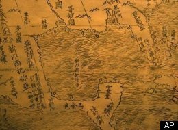 WASHINGTON A rarely seen 400-year-old map that identified Florida as "the Land of Flowers" and put China at the center of the world went on display Tuesday at the Library of Congress. The map created by Matteo Ricci was the first in Chinese to show the Americas. Ricci, a Jesuit missionary from Italy, was among the first Westerners to live in what is now Beijing in the early 1600s. Known for introducing Western science to China, Ricci created the map in 1602 at the request of Emperor Wanli. Ricci's map includes pictures and annotations describing different regions of the world. Africa was noted to have the world's highest mountain and longest river. The brief description of North America mentions "humped oxen" or bison, wild horses and a region named "Ka-na-ta." Several Central and South American places are named, including "Wa-ti-ma-la" (Guatemala), "Yu-ho-t'ang" (Yucatan) and "Chih-Li" (Chile). Ricci gave a brief description of the discovery of the Americas. "In olden days, nobody had ever known that there were such places as North and South America or Magellanica," he wrote, using a label that early mapmakers gave to Australia and Antarctica. "But a hundred years ago, Europeans came sailing in their ships to parts of the sea coast, and so discovered them." The Ricci map gained the nickname the "Impossible Black Tulip of Cartography" because it was so hard to find. This map one of only two in good condition was purchased by the James Ford Bell Trust in October for $1 million, making it the second most expensive rare map ever sold. The library bought another of the world's rarest maps, the Waldseemuller world map, which was the first to name "America," for $10 million in 2003. Story continues below The Ricci map going on display had been held for years by a private collector in Japan and will eventually be housed at the Bell Library at the University of Minnesota. It map symbolizes the first connection between Eastern and Western thinking and commerce, said Ford W. Bell, co-trustee of the fund started by his grandfather, General Mills founder James Ford Bell. Custodians at the Bell Library focus "on the development of trade and how that drove civilization how that constant desire to find new markets to sell new products led to exchanges of knowledge, science, technology and really drove civilization," said Bell, who is also president of the American Association of Museums. "So (the map) fits in beautifully." The map was being shown publicly for the first time in North America. It measures 12 feet by 5 feet, printed on six rolls of rice paper. The Library of Congress rarely exhibits artifacts it does not own because its holdings are so vast, but curators made an exception for the Ricci map. It will be on view through April alongside the Waldseemuller map and later will be shown at the Minneapolis Institute of Arts. The library also will create a digital image of the map to be posted online for researchers and students. Ti Bin Zhang, first secretary for cultural affairs at the Chinese Embassy, said the map represents "the momentous first meeting of East and West" and was the "catalyst for commerce." No examples of the map are known to exist in China, where Ricci was revered and buried. Only a few original copies are known to exist, held by the Vatican's libraries and collectors in France and Japan. ___ On the Net: Library of Congress: http://www.loc.gov/James Ford Bell Library: http://bell.lib.umn.edu/
|
|
|
|
|
15
|
Atlantis / Atlantis in the New Age / Atlantis Insider III-Caribbean City & Bimini
|
on: May 11, 2010, 01:18:36 pm
|
Atlantis Insider III-Caribbean City & Bimini
by Dr. Greg Little I have been asked by many people about the recent report regarding an "underwater city" discovered by satellite imagery in the Caribbean. The report certainly generated a lot of publicity and comment. While I suspected that the imagery was an artifact of the imaging process and perhaps a hoax, I still contacted the author of the article who eventually phoned me. After a long discussion about the location and the process used to obtain the images I conclude that there may, in fact, be a lot more behind the announcement than I initially suspected. But a lot has to be done before anything else can be concluded about it. Due to the location and logistical obstacles involved with the site, my hunch is that it'll be some time before any more details emerge. I have agreed to keep all details about it confidential, so I ask all those interested to not ask me for any more details. Another report was issued in a Miami newspaper regarding divers and a large company (GUE) being hired to search deep water around Bimini for Atlantis. That report is genuine. GUE has actually conducted a series of expeditions in conjuction with the Edgar Cayce organization (the ARE) located in Virginia Beach. The area is adjacent and close to the rectangular formations earlier discovered by archaeologist Bill Donato. In deeper water, about 200-300 feet and more, there are odd formations on elevated areas, in large bowlshape areas, and along submerged ridges. The area has been of interest to the ARE since expeditions led by Dr. Doug Richards, Dr. Joan Hanley, and Bill Donato took place there in the 1990s. However, the depth and other factors have restricted what could be done. The ARE has had side-scan sonar, sub-bottom profiling, and rov video taken of the area. After viewing the film and images, it certainly looks like an interesting area and might have some human-constructed structure there. There are several very intriguing images that have been found with side-scan sonar in that area by both GUE and Donato. As the research is conducted, information about the finds will be released in ARE publications received by ARE members. However, the depths (300 feet) would have been above the sea levels closer to 17,000 BC. The actual 10,000 BC shoreline was at 110-feet or so and that is where we have focused our efforts. In addition, there is another very intriguing area of what do look like building structures located still further to the south. This area will probably be filmed and investigated sometime in 2010. http://www.mysterious-america.net/atlantisinsider1.html
|
|
|
|
|